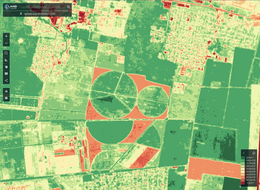
In an age where real-time data drives decision-making across industries, satellite imagery is becoming a vital tool for understanding the world. However, raw imagery is not enough. To create value from satellite data, it needs to be cleaned, analyzed, and transformed into actionable insights. This is where Kawnix steps in as a game-changer.
Kawnix is an AI-powered platform that brings clarity to satellite data through cutting-edge data annotation tools and intelligent workflows. The platform allows users to access cloud-free satellite imagery, annotate datasets with precision, and accelerate analysis using machine learning. Whether you’re monitoring crops, managing disaster response, or building smart cities, Kawnix provides the tools to make satellite data work smarter, faster, and better.
The Challenge With Raw Satellite Imagery
While satellites constantly capture high-resolution images of the Earth, much of that data remains underutilized. The primary reason is that raw imagery is unstructured. Without annotation and contextual labeling, it is nearly impossible for algorithms or analysts to extract meaningful information.
Traditional annotation is a slow, manual process, often handled by large teams working on thousands of image tiles. It requires domain expertise, consistency, and time. As data volumes grow, this manual method is no longer scalable.
Kawnix addresses this challenge by introducing automation, intelligent labeling suggestions, and AI-powered workflows that drastically reduce the time and effort required to process geospatial data.
What Makes Kawnix Unique
Kawnix is not just another image labeling tool. It is a complete geospatial intelligence platform designed for real-world impact. Here are the core features that make Kawnix stand out:
AI-Enhanced Annotation Tools
Kawnix supports advanced annotation formats such as polygons, semantic segmentation, and classification layers. Its AI engine assists by suggesting labels based on existing patterns, improving both speed and consistency.
Cloud-Free Imagery
Cloud cover is one of the biggest limitations in optical satellite imagery. Kawnix offers regularly updated, cloud-free images that improve data quality and ensure accurate annotations every time.
Simple and Intuitive Interface
Users do not need to be GIS experts to work with Kawnix. The platform features an intuitive interface where anyone can load, search, and label satellite data using natural language queries or coordinates.
Scalable for Teams and Enterprises
Kawnix is built for collaboration. Teams can annotate together, manage projects, and maintain a consistent workflow. Data managers can oversee labeling accuracy, assign tasks, and export datasets easily.
Custom Dataset Generation
Users can build their own training datasets for AI models. Whether it’s for detecting buildings, water bodies, road networks, or crop types, Kawnix gives full control over how data is structured and labeled.
Industries That Benefit From Kawnix
Kawnix is a flexible solution with applications across a wide range of sectors:
Agriculture and Food Security
Farmers and agri-tech firms use satellite data to monitor soil conditions, crop stress, irrigation, and yield forecasts. Kawnix enables fast annotation of field-level data to support machine learning models for precision agriculture.
Urban Development and Infrastructure
Governments and city planners rely on annotated imagery to plan roads, buildings, and utilities. Kawnix helps track urban expansion, construction activity, and land-use change with accuracy.
Disaster Preparedness and Response
After floods, wildfires, or earthquakes, accurate and timely analysis of satellite data can save lives. Kawnix speeds up the process of mapping damage, assessing risk, and planning response logistics.
Environmental Monitoring
Climate change, illegal deforestation, and biodiversity loss can be monitored through annotated geospatial data. Kawnix helps researchers and environmental agencies generate clean datasets for conservation and policy work.
Defense and Security
Real-time surveillance, border monitoring, and strategic mapping require accurate geospatial intelligence. Kawnix delivers annotated satellite data that can be used for reconnaissance, logistics, and simulation.
Building the Future of Earth Intelligence
Kawnix is part of a larger movement toward smarter, more accessible Earth observation tools. As AI continues to reshape industries, the demand for high-quality annotated data will only increase. Kawnix bridges the gap between data availability and data usability.
Its combination of satellite imagery, AI automation, and collaborative annotation tools creates a powerful ecosystem for building next-generation geospatial solutions. By making satellite data more understandable and usable, Kawnix enables faster decisions, better planning, and smarter resource management.
Conclusion
Kawnix is redefining how organizations interact with satellite data. Its AI-driven annotation tools, intuitive workflows, and cloud-free imagery create a new standard for geospatial intelligence. As more industries embrace spatial data to power innovation, platforms like Kawnix will be at the center of change.
From agriculture to disaster relief, from urban growth to environmental protection, Kawnix is turning raw satellite imagery into real-world solutions. For any organization seeking to gain insight from above, Kawnix is the intelligent choice.


